A freely suspended Magnet in a Magnetic Compass points towards the North:
- A magnetic compass works because the Earth is like a giant magnet, surrounded by a huge magnetic field. The Earth has two magnetic poles which lie near the North and South poles. The magnetic field of the Earth causes a magnetized ‘needle’ of iron or steel to swing into a north-south position if it is hung from a thread, or if it is stuck through a straw or piece of wood floating in a bowl of water.
- A compass works by utilizing the Earth’s magnetism in order to find directions. Its invention enabled people to perform navigation over long distances, opening up the sea for exploration
- A compass points north because all magnets have two poles, a north pole and a south pole, and the north pole of one magnet is attracted to the south pole of another magnet.
- The Earth is a magnet that can interact with other magnets in this way, so the north end of a compass magnet is drawn to align with the Earth’s magnetic field. Because the Earth’s magnetic North Pole attracts the “north” ends of other magnets, it is technically the “South Pole” of our planet’s magnetic field.
Notes on Earth’s Magnetism:
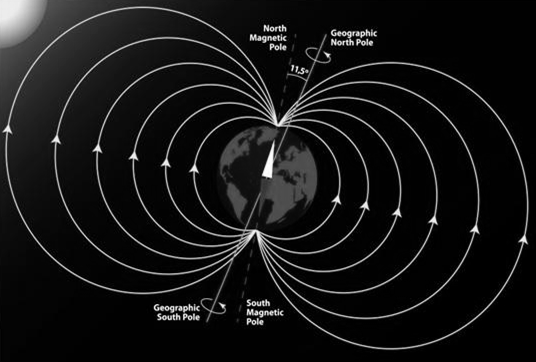
- Earth’s magnetic field, also known as the geomagnetic field, is the magnetic field that extends from the Earth’s interior to where it meets the solar wind, a stream of charged particles emanating from the Sun.
- Its magnitude at the Earth’s surface ranges from 25 to 65 microtesla (0.25 to 0.65 gauss). Roughly speaking it is the field of a magnetic dipole currently tilted at an angle of about 10 degrees with respect to Earth’s rotational axis, as if there were a bar magnet placed at that angle at the center of the Earth.
- Unlike a bar magnet, however, Earth’s magnetic field changes over time because it is generated by a geodynamo (in Earth’s case, the motion of molten iron alloys in its outer core).
- The North and South magnetic poles wander widely, but sufficiently slowly for ordinary compasses to remain useful for navigation.
- However, at irregular intervals averaging several hundred thousand years, the Earth’s field reverses and the North and South Magnetic Poles relatively abruptly switch places.
- These reversals of the geomagnetic poles leave a record in rocks that are of value to paleomagnetists in calculating geomagnetic fields in the past. Such information in turn is helpful in studying the motions of continents and ocean floors in the process of plate tectonics.
‘Variation’ and ‘Deviation’ of Magnetic Compass:
VARIATION:
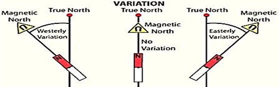
- The true North Pole and the magnetic north pole are not located at the same spot. This variation causes a magnetic compass needle to point more or less away from true north.
The amount the needle is offset is called variation because the amount varies at different points on Earth’s surface. Even in the same locality variation usually does not remain constant, but increases or decreases at a certain known rate annually.
The variation for any given locality, together with the amount of annual increase or decrease, is shown on the compass rose of the chart for that particular locality.
DEVIATION:
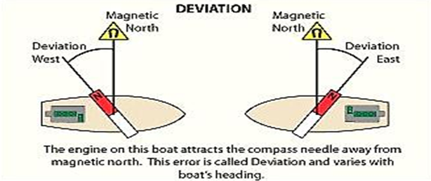
- The amount a magnetic compass needle is deflected by magnetic material in the ship is called deviation.
- Although deviation remains a constant for any given compass heading, it is not the same on all headings. Deviation gradually increases, decreases, increases, and decreases again as the ship goes through an entire 360° of swing.
- The magnetic steering compass is located in the pilothouse, where it is affected considerably by deviation. Usually the standard compass is topside, where the magnetic forces producing deviation are not as strong.
- Courses and bearings by these compasses must be carefully differentiated by the abbreviations PSC (per standard compass), PSTGC (per steering compass), and PGC (per gyrocompass).
- The standard compass provides a means for checking the steering compass and the gyrocompass.
Notes on Ship’s Magnetism:
- On a ship built up of wood, a magnetic compass would point to magnetic north knowing the variation at that place, the magnetic direction corrected and the true direction obtained, the ships built up of steel structures is of two types, soft iron magnetism and the hard iron magnetism.
- Soft iron magnetism is the induced magnetism and hard iron magnetism is the permanent magnetism.
Sketch & label a wet card Magnetic Compass:
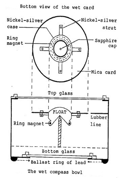
- Necessity:- The dry card compass is too sensitive for steering purposes, especially in bad weather. Even small disturbances cause the dry card to oscillate. In the wet card compass oscillations are damped, without loss of accuracy, by immersing the card in a liquid. The card therefore has a ‘dead beat’ movement.
- The card:- The wet card is made of mica and is only about 15 cm in diameter. The card is attached to nickel- silver float chamber that has a sapphire cap. The cap rests on iridium tipped pivot. The sapphire has a polishing effect on the iridium tip. This arrangement is practically frictionless.
- The directive element:- In modern wet card compasses the directive element is a ring magnet fitted around the base of the float. The ring magnet offers less resistance to movement and causes less turbulence.
- The bowl:- The diameter of the bowl is about 23 cm in order to reduce disturbances caused by turbulence in the liquid during rotation of the card. The top of the bowl is of transparent glass. The bottom is of frosted glass.
- Allowance for expansion:- One method is to have a small accordion – like expansion chamber attached to the bowl. The chamber increases or decreases in volume, as necessary, as the liquid in the bowl expands or contracts due to changes in atmospheric temperature.
- Suspension:- The bowl of the wet card compass is suspended by gimbals. This bowl, being considerably heavier than that of the dry card compass, does not have a glass hemisphere of alcohol and water attached to its underside. Instead, a ballast weight consisting of a ring of lead, enclosed in brass, is attached along with circumference of the underside of the bowl to bring its centre of gravity below the gimbals.
- Care and Maintenance:- The care and maintenance required for a wet card compass and its binnacle is the same as that for a dry card compass. The only changes / differences are:-
- The wet compass card, if found defective owing to stickiness of movement, has to be renewed by the manufacturer or his authorized agent. Hence, no spare wet card is carried. Instead, an entire bowl is carried as a spare.
- In rare cases, a bubble may develop in the wet compass bowl. This has to be removed at the earliest opportunity.
Correctors on a compass binnacle and why are they required, various corrections to be applied to magnetic compass
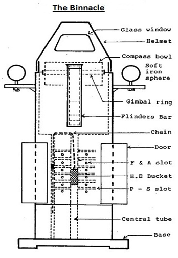
The Binnacle:- The binnacle is a cylindrical container made of teak wood and brass. No magnetic materials are used in its construction. Even the screws are of brass and the nails, copper. The compass bowl is slung inside the top portion of the binnacle. The middle potion is accessible by a door and contains an electric bulb. Light from this bulk passes upwards through a slot, through an orange coloured glass fitted over the slot, through the bottom of the compass bowl, to illuminate the compass card from below. The orange colour ensures that the night vision of the observer is not adversely affected.
- Corrector Magnets:- (See Figure) In the centre of the lower half of the binnacle, there are a number of horizontal holes, both fore & aft and athwartships, for ‘hard iron’ or ‘permanent’ corrector magnets which are meant to offset undesirable, disturbing, magnetic effects caused by the ship’s steel hull. The lower two-thirds of the binnacle has a vertical brass tube, at the centre, in which slides a ‘bucket’. This bucket has some magnets in it called ‘heeling error correctors’. The bucket is held in position by a brass chain.
- Quadrantal Correctors:-
(See Figure) These are two ‘soft iron’ spheres which are fitted in brackets, one on either side of the binnacle. The brackets are slotted so that the distance between the spheres can be altered as desired during compass adjustment. - Flinders Bar:- (See Figure)
This is a soft iron corrector, (diameter about 7.5 to 10 cm) inserted in a 60 cm long brass case, fitted vertically on the forward or on the after part of the binnacle. If the ship has more superstructure abaft the compass, the Flinders bar is fitted on the forward part of the binnacle and vice versa.
Remove an air bubble from the compass bowl
Removal of bubble: A bubble may form in the bowl owing to the fact that some of the liquid has somehow escaped from the bowl. This is a rare occurrence and must be remedied by following the manufacturer’s instructions. In most compasses:
- Tilt the bowl until the ‘filter hole’ comes uppermost. This hole is provided on the side of the bowl. Unscrew the stud/ screw provided.
- Top up with ethyl alcohol. If this is not available, distilled water would do.
- Screw the stud/ screw back into place.
- Gently let the bowl return to upright.
In some modern compasses, small bubbles may be removed as follows:-
- Invert the bowl gently. This would cause the bubble to enter a bubble trap provided for this purposes. Gently return the bowl to upright. The bubble should have disappeared.
Advantages of wet compass over Dry Compass Card
The dry card compass is generally used as a standard compass & the wet card compass as a steering compass. The dry card compass is very sensitive. Even a slight disturbance makes the dry card oscillate. In the wet card compass, the oscillation is damped in the liquid and hence more useful as a steering compass. In some ships, the wet compass is now used as a standard compass, mainly because of the availability of the gyro compass as the main direction indicating instrument.


Why the vessel is required to be swung once in a year to verify Magnetic Compass Deviation Card?
Explanation:-
- Swinging the compass, or swinging the ship (as the operation is sometimes more accurately called as the ship swings around the compass card which, ideally, remains pointing north), involves taking the vessel to a suitable location in open water with plenty of room for maneuvering. With the vessel steady on each of the eight primary compass points, existing compass headings or bearings are compared with what we know the actual magnetic headings or bearings should be, the difference being the deviation.
- During the process, any magnetic fields, created by the ship’s structure, equipment, etc, which cause the compass to deviate are reduced or, if possible, eliminated, by creating equal but opposite magnetic fields using compensating correctors. These are placed inside the compass binnacle or adjacent to the compass:
- Magnets are aligned fore and aft and athwartships to create horizontal magnetic fields to compensate for the permanent horizontal components of the ship’s magnetism.
- Soft iron correcting spheres or plates and the Flinders bar compensate for the induced magnetism caused by the effect the earth’s magnetic field has on the ship’s magnetism.
- Heeling error magnets compensate for the vertical component of the ship’s magnetism.
- The timing and logistics of this operation are often governed by the tide, the weather and other vessels in the vicinity. The time it takes to swing and adjust the compass is also influenced by the condition and accessibility of the compass and correctors, the manoeuvrability of the vessel, the skill of the helmsman and the complexity of, and reasons for, the deviating magnetic fields involved.
- On successful completion of compass swing, a table recording any remaining residual deviation and a statement as to the good working order of the compass will be issued. A current deviation card / certificate of adjustment is a legal requirement on all sea going commercial vessels.
- Deviation can be determined by a number of methods: the sun’s azimuth or known bearings of distant objects, such as a mountain peak or lighthouse are considered most accurate. In certain circumstances, such as poor visibilty, calibration is carried out by making comparisons with other navigation instruments, such as a gyro or GPS compass.
- Using other navigation instruments to find deviation is only satisfactory if the absolute accuracy of these instruments has first been verified, or any known error is factored into the calculations. Most professionals prefer something tangible, such as a fixed landmark, with a known position and bearing to work with.
What is Dip? How compass is kept horizontal in varying latitudes?
Magnetic dip Error:-
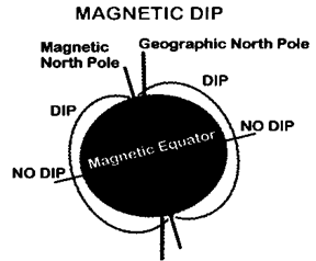
- Magnetic dip is the tendency of the compass needles to point down as well as to the magnetic pole.
- Dip is greatest near the poles and least near the Magnetic Equator.
- The compass card is designed to operate in the horizontal, therefore, any movement from the horizontal plane introduces dip error.
- The needle of your magnetic compass will be parallel with Earth’s surface at the Magnetic Equator, but will point increasing downward as it is moved closer to the Magnetic Pole.
- Northerly turning error is due to the mounting of the compass. Since the card is balanced in fluid, when the vessel turns, the card is also banked as a result of centrifugal force.
- While the card is banked, the vertical component of the Earth’s magnetic field causes the north-seeking ends of the compass to dip to the low side of the turn. When making a turn from a northerly heading, the compass briefly gives an indication of a turn in the opposite direction.
- When making a turn from the south, it gives an indication of a turn in the correct direction but at a faster rate.