Automatic Identification System (AIS) Explanation:
- Very simply, the Automatic Identification System is a broadcast transponder system, operating in the VHF maritime mobile band.
- It is capable of sending information such as identification, position, course, speed and more, to other ships and to shore. AIS operates principally on two dedicated VHF frequencies or channels:
AIS 1 – 161.975 MHz – channel 87B (Simplex, for ship to ship)
AIS 2 – 162.025 MHz – channel 88B (Duplex for ship to shore)
- AIS uses Self-Organizing Time Division Multiple Access (SOTDMA) technology to meet this high broadcast rate and ensure reliable ship-to-ship operation. It normally works in an autonomous and continuous mode, regardless of whether it is operating in the open seas, coastal or inland areas.
- Although only one radio channel is necessary, each station transmits and receives over two radio channels to avoid interference problems and to allow channels to be shifted without communications loss from other ships.
- Each station determines its own transmission schedule (slot), based upon data link traffic history and knowledge of future actions by other stations.
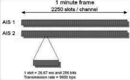
- A position report from one AIS station fits into one of 2250 time slots established every 60 seconds.
- AIS stations continuously synchronize themselves to each other, to avoid overlap of slot transmissions.
- Slot selection by an AIS station is randomized within a defined interval. When a station changes its slot assignment, it pre-announces both the new location and the timeout for that location.
- In this way, new stations including those stations which suddenly come within radio range close to other vessels will always be received by those vessels.
- Each AIS consists of on VHF transmitter, two VHF TDMA receivers, one VHF DSC receiver, and a standard marine electronic communications link to shipboard display and sensor systems.
Working of AIS:-
- AIS is fitted with two receivers, one transmitter VHF DSC receiver Standard marine electronic communication link providing the various input data.
- The AIS transmission uses 9.6 kb GMSK FM over 25 or 12.5kHz channel using HDLC Packet control.
- Each AIS transmits and receives over two radio channel to avoid interference problems.
- Each station determines its own transmission slot based on the data link traffic history and knowledge of future actions by other stations.
- Range of AIS is about 20 NM.
Limitation of AIS:-
- Small crafts may not be fitted with AIS
- AIS might have switched off on other ship
- Erroneous data might have entered
- Accuracy of data received depend on the accuracy of data transmitted
- Error in sensor’s input data,
- Failure of sensors to provide data
- Cell of vessel may be full
Precautions while using AIS in collision avoidance:-
- AIS is an additional source of navigational information. It does not replace other navigational aids.
- Should rely solely on AIS.
- Watches must be kept as per STCW.
- It does not have any impact on the composition of watch arrangement.
- Swapping of targets.
Advantages of AIS:
- AIS helps in collision avoidance with respect to situational awareness, AIS can calculate the CPA & TCPA which can be compared with ARPA.
- Information regarding navigation status cane be beneficial.
- By virtue of AIS vessels can be positively identified.
- AIS reduced the work load associated with verbal reporting system required by the VTS.
- AIS contributes to Maritime security, authorities can monitor the movement of the vessels, multiple AIS coast stations can be linked together to get the extended surveillance.
- AIS can pick up targets even during heavy weather & restricted visibility especially due to rain etc.
- AIS can pick up targets beyond small islands & bends.
- Problem on target swap (for ARPA) will not be experienced in case of AIS.
- No problem of range discrimination or bearing discrimination.
- Pseudo AIS can be used to generate virtual buoys to indicate dangers.
- AIS can also be installed on light houses, beacons for positive identification of these marks.
- Pseudo AIS can also be used to generate target in case of SAR operations.
- AIS can be used for meteorological & navigational information.
- AIS can be interfaced with VDR, ECDIS & radar.
Limitations of AIS:
- Small crafts may not be fitted with AIS
- AIS might have switched off on other ship
- Erroneous data might have entered
- Accuracy of data received depend on the accuracy of data transmitted
- Error in sensor’s input data,
- Failure of sensors to provide data
- Cell of vessel may be full
Precautions while using AIS in collision avoidance:
- Do not rely on AIS as the sole information system, making use of all safety-relevant information available.
- AIS is an additional source of navigational information. It does not replace other nav aids.
- Watches must be kept as per STCW.
- It does not have any impact on the composition of watch arrangement.
- Swapping of targets.


Use of AIS in collision avoidance and SAR operations:
Use of AIS in Collision avoidance: AIS has potential to significantly contribute to safety of navigation. It provides positive identification of targets fitted with AIS along with their static and dynamic information.
This enhances the navigational effectiveness and it can greatly improve situational awareness and decision making abilities. AIS also assists OOW in tracking and monitoring targets, as it also provides information on CPA and TCPA.
Use of AIS in SAR operations:
- SAR operations can be used for receiving messages from an AIS-SAR transmitter (SART), which have built in GPS receivers to derive accurate positioning information, on survival craft.
- In combined aerial and surface searches AIS may allow the direct presentation of the position on other displays, such as radar, electronic chart systems and ECDIS.
- AIS-SART facilitates the task of SAR craft in rescuing distressed seafarers.
- For ships in distress without AIS, the on scene co-ordinator could create an AIS target.
Contents & broadcast intervals for each message type for a class A AIS:
- A Class A AIS unit broadcasts the following information every 2 to 10 seconds while underway and every 3 minutes while at anchor at a power level of 12.5 watts.
- The information broadcast includes:
- MMSI number – unique reference able identification
- Navigation status – not only are “at anchor” and “underway using engine“ currently defined, but “not under command” is also currently defined.
- Rate of turn – right or left, 0 to 720 degrees per minute.
- Speed over ground – 1/10 knot resolution from 0 to 102 knots.
- Position accuracy – differential GPS or other and an indication if RAIM processing is being used Longitude – to 1/10000 minute and Latitude – to 1/10000 minute.
- Course over ground – relative to true north to 1/10th degree.
- True Heading – 0 to 359 degrees derived from gyro input.
- Time stamp – The universal time to nearest second that this information was generated.
- In addition, the Class A AIS unit broadcasts the following
- information every 6 minutes:
- MMSI number – same unique identification used above, links the data above to described vessel.
- IMO number – unique reference able identification (related to ship’s construction).
- Radio call sign – international call sign assigned to vessel, often used on voice radio.
- Name – Name of ship, 20 characters are provided.
- Type of ship/cargo – there is a table of possibilities that are available.
- Dimensions of ship – to nearest meter.
- Location on ship where reference point for position reports is located.
- Type of position fixing device – various options from differential GPS to undefined.
- Draught of ship – 1/10 meter to 25.5 meters [note “air-draught” is not provided].
- Destination – 20 characters are provided.
- Estimated time of Arrival at destination – month, day, hour, and minute in UTC.
AIS & LRIT Comparison:-
| AIS | LRIT |
| Satellite | VHF |
| Global | Only where AIS coverage is provided |
| Secure Data | Public Data |
| Position, IMO Number, Date Time | Position, IMO Number, Date Time, Vessel Type, Speed, Course |
| Unlimited range | Line of sight, up to 40NM |
| Flag State Owns Data | Anyone can see data |
| Maritime Security and Awareness | Navigation and Anti-collision Tool |
With Respect to AIS explain the followings: Dynamic Message
The dynamic data are sent as per the ship’s navigational status and speed and are as follows:
- When at anchor every three minutes.
- 0-14 kts-every 12 seconds
- 14-23 kts-every 6 seconds
- 14-23 kts and changing course every 2 seconds
- 23+ kts every 2 seconds