Electronic Chart Display and Information System (ECDIS) Explanation:-
- Electronic Chart Display and information Systems (ECIDS) means a navigation information system which with adequate back-up arrangements can be accepted as complying with the up-to-date chart required by regulation V/20 of the 1974 SOLAS Convention, by displaying selected information from a system electronic navigational chart (SENC) with positional information from navigation sensors to assist the mariner in route Monitoring, and if required display additional navigation related information.
- Generation of ECDIS:-
- The electronic navigation chart is the data base standardized as to content, structure and format and is issued by the hydrographic office (HO) under the authority of the government, the ENC contains all the chart information necessary for safe navigation and may contain supplementary information in addition to that contained in the paper chart (e.g. list of lights and fog signals etc.) which may be considered necessary for safe navigation.
- The system electronic navigation chart (SENC) is the data base resulting from transformation of the ENC by the ECDIS for appropriate use, updates to the ENC by appropriate means and other data added by the mariner. It is the data base that is actually accessed by the ECDIS for the display generations & other navigational functions and is equivalent to an up-to-date paper chart.
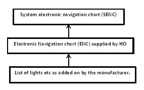
ECDIS is basically a CPU with a monitor to display electronic chart, SENC is an integral part and below figure can be referred for better understanding which shows that SENC is interfaced with various equipment as mentioned below results in an ECDIS.
Advantages of Electronic Chart Display and Information System (ECDIS):
- Availability: One of the great advantages of ECDIS over paper charts is the availability of electronic charts – especially when voyage orders are received at the last minute.
- Speed and Accuracy: With ECDIS as the primary source of navigation, the Navigating Officer can plan and summarise the passage much faster than on Paper Charts. Daily reporting data such as Distance to Go, Distance Covered, Average Speed, etc. can be done quickly with hardly any effort.
- Corrections: The Navigating Officer now receives weekly updates to the Electronic Charts via Email which he has to download onto a zip drive and upload them to the ECDIS. Even the dreaded T&P notices are now shown electronically on the ECDIS.
- Continuous Monitoring of Vessel’s Position: The ECDIS is interfaced with both the vessel’s independent GPS transceivers, thereby making the system work even if one fails.
- Anti-Grounding Alarms and Settings: The ability of the ECDIS to warn the user of approaching shallow waters make it one of the most useful equipment on the bridge.
- User Determined Alarm Settings: While there are certain safety critical alarms that are ON by defaults and cannot be changed, there are a host of other alarms and warnings which may be switched on or off by the User depending on the situation.
- Enhances Search and Rescue Capability onboard: Modern ECDIS units have the option of interfacing NAVTEX and EGC with the ECDIS display. Warnings and Alerts are automatically displayed on the ECDIS screen, whilst at the same time giving an audible and visual indication on the unit itself.
- Cost Efficient: Although, Electronic charts are by no means cheap, they still have an edge over paper charts dollar for dollar.
- Environmentally Friendly: The ECDIS does pack in a strong punch in reducing the carbon footprint of every vessel which goes paperless.
Disadvantages of Electronic Chart Display and Information System (ECDIS):
- Over-Reliance: A vessel could have switched off its AIS and hence might not be displayed on the ECDIS. If the Radar Overlay is not turned on, the vessel will just not be seen on the ECDIS display. Hence, it is very critical that Navigators continue to maintain an efficient lookout and a good radar watch.
- Garbage In Garbage Out (GIGO): Erroneous position inputs from the GPS or loss of GPS signal can have grave consequences with the ECDIS going in DR mode. If the alarm is missed out, the result can be disastrous.
- Wrong Settings: Feeding in wrong parameters for safety critical settings such as the Safety Depths, Safety Contours etc can give a false sense of safety.
- Alarm Deafness: If alarms start going off too frequently, the navigator could end up in a dangerous situation called Alarm Deafness.
- System Lag: Modern ECDIS software can have a lot of data to display and with various equipment interfaced with the ECDIS, the system can slow down very easily leading to system lag.
- Different Types: Different vessels will have different types of ECDIS equipment.
- Anomalies: Every navigator needs to be aware of the anomalies present in that particular equipment. It could be a simple use of the SCAMIN (Scale Minimum) function or something serious where certain depths or symbols might not be visible at a particular scale or appear differently.
- Information Overload: It is very easy to over feed information on the ECDIS. A lot of data which was earlier marked on charts such as position for calling Master notices to Engine Room, Echo Sounder Switch on points, Port Control VHF channels etc now have to be fed on the ECDIS.
Advantages of ECDIS over conventional Paper Charts:
- Position fixing can be done at required interval without manual interference.
- Continuous monitoring of the ship’s position.
- When interfaced with ARPA/RADAR, target can be monitored continuously.
- If two position fixing system are available, the discrepancy in two systems can be identified.
- Charts can be corrected with help of CD/Online.
- Passage planning can be done on ECDIS without referring to other publications.
- Various alarms can be set on ECDIS.
- Progress of the passage can be monitored in more disciplined manner, since other navigational data is available on ECDIS.
- Various alarms can be activated to draw the attention of OOW.
- More accurate ETA can be calculated.
- Anchoring can be planned more precisely.
“Zones of Confidence” in ECDIS:-
- The information presented in a reliability diagram requires knowledge of past and present hydrographic surveying practices — something most mariners neither have nor should need. To address this, the Australian Hydrographic Service developed a system known as “zones of confidence” that has since been adopted internationally.
- On each nautical chart the accuracy and reliability of the information used to compile the chart is shown on a “zone of confidence” (ZOC) diagram. Within official electronic navigational charts (ENCs), the same information is shown as a layer that can be switched on and off by the mariner.
- ZOC categories warn mariners which parts of the chart are based on good or poor information and which areas should be navigated with caution. The ZOC system consists of five quality categories for assessed data, with a sixth category for data which has not been assessed.
- The table accompanying the ZOC diagram on each chart summarizes the meaning of the ZOC categories.
Define ENC as applicable to ECDIS:
Electronic Navigational Chart (ENC) means the database, standardized as to content, structure and format, issued for use with ECDIS on the authority of government authorized hydrographic offices. The ENC contains all the chart information necessary for safe navigation and may contain supplementary information in addition to that contained in the paper chart (e.g. sailing directions) which may be considered necessary for safe navigation. Vector charts are an example.
Define SENC as applicable to ECDIS:
System Electronic Navigational Chart (SENC) means a database resulting from the transformation of the ENC (a vector chart) by ECDIS for appropriate use, updates to the ENC by appropriate means and other data added by the mariner. It is the database that is actually accessed by ECDIS for the display generation and other navigational functions and is the equivalent to an up-to-date paper chart. The SENC may also contain information from other sources.
Define Standard Display as applicable to ECDIS:
Standard Display means the SENC information that should be shown when a chart is first displayed on ECDIS. Depending upon the needs of the mariner, the level of the information it provides for route planning or route monitoring may be modified by the mariner.
Define Display Base as applicable to ECDIS:
Display Base means the level of SENC information which cannot be removed from the display, consisting of information which is required at all times in all geographic areas and all circumstances. It is not intended to be sufficient for safe navigation.
Define Vector Chart as applicable to ECDIS:
A vector chart is a digital database of all the objects (points, lines, areas, etc.) represented on a chart. Vector charts store information, such as isolated dangers, depths, depth contours, coastline features, cables and pipelines etc in separate layers which can be displayed as per the user’s requirements. Vector charts are also referred to as intelligent charts as they can be interrogated for information not displayed but stored in it’s memory.
Define Raster Chart as applicable to ECDIS:
Raster Chart data is created by scanning the information on a paper chart and storing this information in the form of pixels. Many thousands of pixels together make a flat digital image. Each pixel contains all the data for a particular point: colour, brightness etc. They are also geographically referenced which makes the raster chart identical in every way to the paper chart on which it is based. Raster charts cannot be manipulated or queried. Also referred to as the Raster Chart Display System (RCDS), the information is contained in one single layer only. Information can only be added to this type of chart.