Posted on

Emergency Position Indicating Radio Beacon (EPIRB) on Ship

Emergency Position Indicating Radio Beacon (EPIRB):

Emergency Position Indicating Radio Beacon (EPIRB) on ships
  • EPIRB stands for Emergency Position Indicating Radio Beacon.
  • An EPIRB is meant to help rescuers locate you in an emergency situation, and these radios have saved many lives since their creation in the 1970s.
  • Boaters are the main users of EPIRBs.
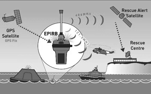
  • A modern EPIRB is a sophisticated device that contains:
    • A 5-watt radio transmitter operating at 406 MHz (see How the Radio Spectrum Works for details on frequencies).
    • A 0.25-watt radio transmitter operating at 121.5 MHz.
  • A GPS receiver once activated, both of the radios start transmitting. Approximately 24,000 miles (39,000 km) up in space, a GOES weather satellite in a geosynchronous orbit can detect the 406-MHz signal. Embedded in the signal is a unique serial number, and, if the unit is equipped with a GPS receiver, the exact location of the radio is conveyed in the signal as well. If the EPIRB is properly registered, the serial number lets the Coast Guard know who owns the EPIRB. Rescuers in planes or boats can home in on the EPIRB using either the 406-MHz or 121.5-MHz signal.
Posted on

Vessel Traffic Service (VTS)

How do VTS contribute to safety of life at sea?

VESSEL TRAFFIC SERVICE (VTS):- A vessel traffic service (VTS) is a marine traffic monitoring system established by harbour or port authorities, similar to air traffic control for aircraft. Typical VTS systems use radar, closed-circuit television (CCTV), VHF radiotelephony and automatic identification system to keep track of vessel movements and provide navigational safety in a limited geographical area

SOLAS CHAPTER V – REGULATION 12 – Vessel traffic services:-

  1. Vessel traffic services (VTS) contribute to safety of life at sea, safety and efficiency of navigation and protection of the marine environment, adjacent shore areas, work sites and offshore installations from possible adverse effects of maritime traffic.
  2. Contracting Governments undertake to arrange for the establishment of VTS where, in their opinion, the volume of traffic or the degree of risk justifies such services.
  3. Contracting Governments planning and implementing VTS shall, wherever possible, follow the guidelines developed by the Organization*. The use of VTS may only be made mandatory in sea areas within the territorial seas of a coastal State.
  4. Contracting Governments shall endeavor to secure the participation in, and compliance with, the provisions of vessel traffic services by ships entitled to fly their flag.
  5. Nothing in this regulation or the guidelines adopted by the Organization shall prejudice the rights and duties of Governments under international law or the legal regimes of straits used for international navigation and archipelagic sea lanes.

Benefits of implementing a VTS

The purpose of VTS is to improve the maritime safety and efficiency of navigation, safety of life at sea and the protection of the marine environment and/or the adjacent shore area, work sites and offshore installations from possible adverse effects of maritime traffic in a given area. VTS may also have a role to play in security.

The benefits of implementing a VTS:-

  • It allows identification and monitoring of vessels, strategic planning of vessel movements and provision of navigational information and navigational assistance.
  • It can assist in reducing the risk of pollution and, should it occur, coordinating the pollution response. Many authorities express difficulty in establishing justifiable criteria for identifying whether VTS is the most appropriate tool to improve the safety and efficiency of navigation, safety of life and the protection of the environment.
  • A VTS is generally appropriate in areas that may include any, or a combination, of the following:
    • high traffic density;
    • traffic carrying hazardous cargoes;
    • conflicting and complex navigation patterns;
    • difficult hydrographical, hydrological and meteorological elements;
    • shifting shoals and other local hazards and environmental considerations;
    • interference by vessel traffic with other waterborne activities;
    • number of casualties in an area during a specified period;
    • existing or planned vessel traffic services on adjacent waterways and the need for cooperation between neighbouring states, if appropriate;
    • narrow channels, port configuration, bridges, locks, bends and similar areas where the progress of vessels may be restricted; and
    • existing or foreseeable changes in the traffic pattern in the area.

Objectives of VTS:

  1. The purpose of vessel traffic services is to improve the safety and efficiency of navigation, safety of life at sea and the protection of the marine environment and/or the adjacent shore area, worksites and offshore installations from possible adverse effects of maritime traffic.
  2. A clear distinction may need to be made between a Port or Harbour VTS and a Coastal VTS. A Port VTS is mainly concerned with vessel traffic to and from a port or harbour or harbours, while a Coastal VTS is mainly concerned with vessel traffic passing through the area. A VTS could also be a combination of both types. The type and level of service or services rendered could differ between both types of VTS; in a Port or Harbour VTS a navigational assistance service and/or a traffic organization service is usually provided for, while in a Coastal VTS usually only an information service is rendered.
  3. The benefits of implementing a VTS are that it allows identification and monitoring of vessels, strategic planning of vessel movements and provision of navigational information and assistance. It can also assist in prevention of pollution and co-ordination of pollution response. The efficiency of a VTS will depend on the reliability and continuity of communications and on the ability to provide good and unambiguous information. The quality of accident prevention measures will depend on the system’s capability of detecting a developing dangerous situation and on the ability to give timely warning of such dangers.
  4. The precise objective of any vessel traffic service will depend upon the particular circumstances in the VTS area and the volume and character of maritime traffic as set forth in 3.2 of these Guidelines and Criteria.

Use of VTS in navigation:

  • Automatic Identification System (AIS) is a system that makes it possible to monitor and track ships from suitably equipped ships, and shore stations. AIS transmissions consist of bursts of digital data ‘packets’ from individual stations, according to a pre-determined time sequence.
  • AIS makes navigation safer by enhancing situational awareness and increases the possibility of detecting other ships, even if they are behind a bend in a channel or river or behind an island in an archipelago.
  • AIS can also solve the problem inherent with radars, by detecting smaller craft, fitted with AIS, in sea and rain clutter.

Reporting procedures of VTS and SRS:

Reporting procedures of VTS and SRS:- Standard Reporting Procedures, IMO Resolution A.851 (20) – ‘General Principles for Ship Reporting Systems and Ship Reporting Requirements’.

Types of Communication Messages and Message Markers:-

  • To facilitate shore-to-ship and ship-to-shore communication in a VTS environment, one of the following eight message markers should be used to increase the probability of the purpose of the message being properly understood.
  • It is at the discretion of the shore personnel or the ship’s officer whether to use one of the message markers and, if so, which marker is applicable to the situation.
  • If used, the message marker is to be spoken preceding the message or the corresponding part of the message.
  • The contents of all messages directed to a vessel should be clear; IMO Standard Marine Communication Phrases should be used where practicable.

Elements of the Ship’s Routeing System:

The objective of ships’ routeing is to “improve the safety of navigation in converging areas and in areas where the density of traffic is great or where freedom of movement of shipping is inhibited by restricted sea room, the existence of obstructions to navigation, limited depths or unfavourable meteorological conditions”. Ships routeing systems can be established to improve safety of life at sea, safety and efficiency of navigation, and/or increase the protection of the marine environment.

Elements used in traffic routeing systems include:

  • Traffic separation scheme: a routeing measure aimed at the separation of opposing streams of traffic by appropriate means and by the establishment of traffic lanes.
  • Traffic lane: an areas within defined limits in which one-way traffic is established, natural obstacles, including those forming separation zones, may constitute a boundary.
  • Separation zone or line: a zone or line separating traffic lanes in which ships are proceeding in opposite or nearly opposite directions; or separating a traffic lane from the adjacent sea area; or separating traffic lanes designated for particular classes of ship proceeding in the same direction.
  • Roundabout: a separation point or circular separation zone and a circular traffic lane within defined limits.
  • Inshore traffic zone: a designated area between the landward boundary of a traffic separation scheme and the adjacent coast.
  • Recommended route: a route of undefined width, for the convenience of ships in transit, which is often marked by centreline buoys.
  • Deep-water route: a route within defined limits which has been accurately surveyed for clearance of sea bottom and submerged articles.
  • Precautionary area: an area within defined limits where ships must navigate with particular caution and within which the direction of flow of traffic may be recommended.
  • Area to be avoided: an area within defined limits in which either navigation is particularly hazardous or it is exceptionally important to avoid casualties and which should be avoided by all ships, or by certain classes of ships.

Before Implementing or starting a TSS or Vessel routeing system the below mentioned information should be collected:

  1. Data about the area and problem or threat thereof:
    • Resources within are
    • Potential navigation hazard.
    • Environmental factors
  2. Data about the ship traffic (e.g., vol., traffic patterns)
  3. Information regarding existing measures
  4. Foreseeable changes in traffic patterns
  5. Information regarding incident history
  6. Existing aids to navigation
  7. Charts (are they up to date?)
  8. IMO documents (models)


VTS Category – Information Service:

Defined by IMO as ‘a service to ensure that essential information becomes available in time for on-board navigational decision-making’. The information service comprises broadcasts of information at fixed times or when deemed necessary by the VTS Authority or at the request of a vessel, and may include for example :

  1. Reports on the position, identity and intentions of other traffic;
  2. Waterway conditions;
  3. Weather;
  4. Navigational hazards;
  5. Any other factors that may influence the vessel’s transit.

Navigational Assistance Service: Defined by IMO as ‘a service to assist on-board navigational decision-making and to monitor its effects, especially in difficult navigational or meteorological circumstance or in case of defect or deficiencies.’ There may be occasions when an increased or new risk makes it appropriate to enhance the service through the additional provision of a Navigational Assistance Service. The IMO Resolution explains the key tenets of this service as:

  1. A service that is intended to assist in the navigational decision making process on board and to monitor its effects.
  2. Particularly relevant to:
    • Difficult navigational circumstances;
    • Difficult meteorological conditions;
    • Vessel defects or deficiencies.
  3. A service that is rendered at the specific request of a vessel or by a VTS Authority when deemed necessary.
  4. A service that is provided only on specified occasions and under clearly defined circumstances.
  5. The beginning and end of navigational assistance should be clearly stated by the vessel or the VTS and acknowledged by the other party.

The IALA VTS Manual indicates that Navigational Assistance Service can fall into one of two categories, depending on whether navigational information or advice is given. Navigational Assistance Service consisting only of the giving of navigational information is referred to in this guidance as Contributory. Navigational Assistance Service consisting of the giving of navigational advice as well as navigational information is referred to as Participatory. The definitions, particularly of the Participatory service, are open to interpretation and for the avoidance of doubt their meaning is refined and expanded as follows.

  1. Contributory Navigational Assistance Services:

A Contributory Navigational Assistance Service is solely the provision of factual navigational information to assist the on-board decision making process.

The information is provided either in response to a specific request from a vessel or when the VTS Authority perceives that the information would be of use to the vessel.

A Contributory Navigational Assistance Service may include information on :

  1. Courses and speeds made good;
  2. Positions relative to fairway axis and waypoints;
  3. Positions, identities and intentions of surrounding traffic;
  4. Warnings of dangers.
  1. Participatory Navigational Assistance Service:

In a Participatory Navigational Assistance Service, the VTS can become involved in the on-board decision making process by providing navigational advice. Through the exchange of information between vessel and VTS, an agreed course of action may emerge. However, any recommendations from the VTS must be result orientated and must not include specific instructions on courses to steer and speed through the water. As with the Contributory service, it is provided on specific request or when perceived necessary by the VTS Authority, in the interests of safety.

Dependent on the complexity of the situation and the level of risk mitigation required, consideration should be given to the following :

(1) Authorisations of operators providing the service and recording of such authorisations;

(2) The need to reflect this category of service in the On the Job Training of VTS Operators;

(3) Operator work load during Participatory Navigational Assistance Service, including other responsibilities and activities, and the number of vessels being monitored or advised;

(4) Use of a discrete frequency;

(5) Increased traffic restrictions;

(6) The requirements of the Pilotage Act 1987.

Traffic Organisation Service: Defined by IMO as ‘a service to prevent the development of dangerous maritime traffic situations and to provide for the safe and efficient movement of vessel traffic within the VTS Area.’

The provision of a Traffic Organisation Service includes a comprehensive and dedicated service, throughout the declared service period, without which the long term planning of traffic movement and developing situation would not be possible. This service is, by its nature, more comprehensive than an Information Service, the capability of which it necessarily includes.

Where the risks identified through the formal risk assessment are such that the only appropriate mitigating measure is the provision of service that monitors vessel traffic movement and enforces adherence to governing rule and regulation, a Traffic Organisation Service should be considered appropriate.

A Traffic Organisation Service is concerned with, for example :

  1. Forward planning of vessel movements;
  2. Congestion and dangerous situations;
  3. The movement of special transports;
  4. Traffic clearance systems;
  5. VTS sailing plans;
  6. Routes to be followed;
  7. Adherence to governing rules and regulations.

Instructions given as part of a Traffic Organisation Service shall be result orientated, leaving the details of the execution to the vessel.

Posted on

Rate of Turn Indicator on Ship (ROTI)

Rate of Turn Indicator

Introduction:

  • IMO Recommendations on passage planning lay stress on controlled navigation. The passages in narrow channels or harbors are either along straight courses or along arcs of circles.
  • As per SOLAS 2000 Amendment Chapter V Regulation 19.2.9, it is mandatory for ships over 50,000 GRT to have a rate of turn indicator. IMO recommends that large alteration of courses have to be planned along circular tracks with wheel over point marked.
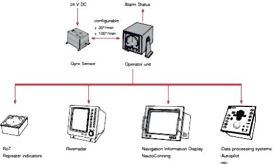
  • The Rate of Turn Indicator (ROTI) is a device which indicates the instantaneous rate at which the ship is turning. It is fitted on ship as an independent fitment integrated with the steering gear/auto pilot.
Rate of Turn Indicator of Ship
  • When the wheel is turned over, the ship actually traverses along a curved track rather than performing a sharp turn about a point. It is very useful knowing the nature of this traversed path the ship takes which can help in planning:
    • The desired turn with given radius
    • Desired speed of the vessel to execute the planned turn.
    • When to apply the turn (wheel over point).

RATE OF TURN FORMULAE:

ROT = v/R

Where,

v – Speed of the vessel .

R – Radius from a fixed point around which to turn the ship.

Note: ROT is directly proportional to the speed.

ROT is inversely proportional to radius.


Use of ROTI (Rate Of Turn Indicator):-

  1. The rate of turn indicator is equipment which indicates the instantaneous rate at which the ship is turning.
  2. This indicator is fed 60 to 200 pulses per minute from the steering repeater and from this input it works out the instantaneous rate of turn.
  3. The dial is marked usually 0O to 60O on either side. As per IMO performance standard the dial should be marked not less than 0O to 30O per minute on either side and graduated in intervals of 1O per minute.
  4. As we know that when ship turn she actually traverses some distance round the arc of a circle and cannot execute a sharp turns about a point.
  5. When ship is making a turn it precise the ship track uncertain due to her characteristic, condition, weight and UKC.
  6. Therefore navigator uses the touch of ship track during the turn that is uncertain of position until the ship is steadied on the new course.
  7. IMO recommends for passage planning is not only monitor the position on straight course but also on curve section of passage. This can be achieved by the technique called radius turn by the help of roti and ship’s log.

Posted on

Ship Reporting System

Ship Reporting System (SRS):

  • A ship reporting system enables the SMC to quickly:
    • Identify vessels in the vicinity of a distress situation, along with their positions, courses, and speeds
    • Be aware of other information about the vessels, which may be valuable (whether a doctor is aboard, etc.)
    • Know how to contact the vessels
  • Masters of vessels are urged to send regular reports to the authority operating a ship reporting system for SAR.

The Automated Mutual-Assistance Vessel Rescue (AMVER) System:-

  • AMVER is a worldwide system operated exclusively to support SAR and make information available to all RCCS.
    • There is no charge for vessels to participate in, nor for RCCs to use AMVER
    • Many land-based providers of communications services world-wide relay ship reports to AMVER free of charge.
  • Any merchant vessel of 1,000 gross tons or more on any voyage of greater than 24 hours is welcome to participate.
  • Benefits of participation include:
    • Improved likelihood of rapid aid during emergencies
    • Reduced number of calls for assistance to vessels unfavorably located to respond
    • Reduced response time to provide assistance.

Types of Reports does a ship need to send out:

Reports should be sent as follows:

  • Sailing plan (SP) – Before or as near as possible to the time of departure from a port within a reporting system or when entering the area covered by a system.
  • Position report (PR) – When necessary to ensure effective operation of the system.
  • Deviation report (DR) – When the ship’s position varies significantly from the position that would have been predicted from previous reports, when changing the reported route, or as decided by the master.
  • Final report (FR) – On arrival at destination and when leaving the area covered by a system.
  • Dangerous goods report (DG) – When an incident takes place involving the loss or likely loss overboard of packaged dangerous goods, including those in freight containers, portable tanks, road and rail vehicles and shipborne barges, into the sea.
  • Harmful substances report (HS) – When an incident takes place involving the discharge or probable discharge of oil (Annex I of MARPOL) or noxious liquid substances in bulk (Annex II of MARPOL).
  • Marine pollutants report (MP) – In the case of loss or likely loss overboard of harmful substances in packaged form, including those in freight containers, portable tanks, road and rail vehicles and shipborne barges, identified in the International Maritime Dangerous Goods Code as marine pollutants (Annex III of MARPOL).
  • Any other report – Any other report should be made in accordance with the system procedures as notified in accordance with paragraph 9 of the General Principles.

Importance of Ship Reporting Systems for safe navigation:

  1. Ship reporting systems contribute to safety of life at sea, safety and efficiency of navigation and/or protection of the marine environment. A ship reporting system, when adopted and implemented in accordance with the guidelines and criteria developed by the Organization pursuant to this regulation, shall be used by all ships, or certain categories of ships or ships carrying certain cargoes in accordance with the provisions of each system so adopted.
  2. The Organization is recognized as the only international body for developing guidelines, criteria and regulations on an international level for ship reporting systems. Contracting Governments shall refer proposals for the adoption of ship reporting systems to the Organization. The Organization will collate and disseminate to Contracting Governments all relevant information with regard to any adopted ship reporting system.
  3. The initiation of action for establishing a ship reporting system is the responsibility of the Government or Governments concerned. In developing such systems provision of the guidelines and criteria developed by the Organization shall be taken into account.
  4. Ship reporting systems not submitted to the Organization for adoption do not necessarily need to comply with this regulation. However, Governments implementing such systems are encouraged to follow, wherever possible, the guidelines and criteria developed by the Organization. Contracting Governments may submit such systems to the Organization for recognition.
  5. Where two or more Governments have a common interest in a particular area, they should formulate proposals for a co-ordinated ship reporting system on the basis of agreement between them. Before proceeding with a proposal for adoption of a ship reporting system, the Organization shall disseminate details of the proposal to those Governments which have a common interest in the area covered by the proposed system. Where a co-ordinated ship reporting system is adopted and established, it shall have uniform procedures and operations.
  6. After adoption of a ship reporting system in accordance with this regulation, the Government or Governments concerned shall take all measures necessary for the promulgation of any information needed for the efficient and effective use of the system. Any adopted ship reporting system shall have the capability of interaction and the ability to assist ships with information when necessary. Such systems shall be operated in accordance with the guidelines and criteria developed by the Organization pursuant to this regulation.
  7. The master of a ship shall comply with the requirements of adopted ship reporting systems and report to the appropriate authority all information required in accordance with the provisions of each such system.
  8. All adopted ship reporting systems and actions taken to enforce compliance with those systems shall be consistent with international law, including the relevant provisions of the United Nations Convention on the Law of the Sea.
  9. Nothing in this regulation or its associated guidelines and criteria shall prejudice the rights and duties of Governments under international law or the legal regimes of straits used for international navigation and archipelagic sea lanes.
  10. The participation of ships in accordance with the provisions of adopted ship reporting systems shall be free of charge to the ships concerned.
  11. The Organization shall ensure that adopted ship reporting systems are reviewed under the guidelines and criteria developed by the Organization.

Explanation of how the ship reporting system provides the necessary information for search & rescue in case of distress:

Ship Reporting System:-

  • A ship reporting system enables the SMC to quickly:
    • identify vessels in the vicinity of a distress situation, along with their positions, courses, and speeds
    • be aware of other information about the vessels, which may be valuable (whether a doctor is aboard, etc.)
    • know how to contact the vessels.
  • Masters of vessels are urged to send regular reports to the authority operating a ship reporting system for SAR.

The Automated Mutual-Assistance Vessel Rescue (AMVER) System:-

  • AMVER is a worldwide system operated exclusively to support SAR and make information available to all RCCS.
    • there is no charge for vessels to participate in, nor for RCCs to use AMVER
    • many land-based providers of communications services world-wide relay ship reports to AMVER free of charge.
  • Any merchant vessel of 1,000 gross tons or more on any voyage of greater than 24 hours is welcome to participate.
  • Benefits of participation include:
    • improved likelihood of rapid aid during emergencies
    • reduced number of calls for assistance to vessels unfavorably located to respond
    • reduced response time to provide assistance.


Short notes on INSPIRES with respect to Ship Reporting System:

INDIAN Ship position and information reporting system (INSPIRES) :

Indian navy in co-ordination with DG of Shipping has established INSPIRES to exercise effective open ocean vessel management, to provide security to vessel, weather forecast to enhance safety of navigation and monitor incidence of pollution. An Indian Naval communication center (COMCENs) Mumbai and Vizag are functioning as the shore stations for receiving INSPIRES messages from vessels. All Indian vessels including coasting/ fishing vessels of tonnage 300 GRT and above shall participate in this reporting system. All vessels other than Indian ships of tonnage 100 GRT and above are encouraged to participate in this reporting system.

INDIAN SHIP REPORTING SYSTEM:

INDIAN SHIP POSITION AND INFORMATION REPORTING SYSTEM (INSPIRES) SHIP REPORTING SYSTEM FOR SAR (INDSAR):

The INSPIRES has been established to achieve the following objectives:

  • To provide up to date information on shipping for search and rescue.
  • For effective vessel traffic management service.
  • For weather forecasting.
  • For prevention and containment of marine pollution.

This reporting system has wider area of coverage in the Indian Ocean. An Indian Naval Communication Centre (COMCENs) Mumbai and Vishakhapatnam are functioning as the shore stations for receiving INSPIRES messages from all vessels.


Posted on

Marine Sextant

Marine Sextant Explanation

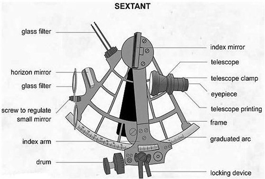
Sextant Diagram
Sextant Diagram
Sextant is a precision instrument used for –
  • measuring altitudes of celestial bodies and
  • horizontal angles between terrestrial objects
  • vertical angles of terrestrial objects

Principle of Sextant:

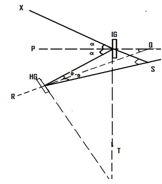
  1. When a ray of light is reflected by a plane mirror, the angle of incidence is equal to the angle of reflection, while the incident ray, reflected ray and the normal lying in the same plane.
  2. When a ray of light, suffers two successive reflections in the same plane, by two plane mirrors, the angle between the incident ray and the final ray is twice the angle between the mirrors.

Formulae for Sextant:-

Sextant Formulae
Sextant Formulae

To prove angle    S = twice angle Q

                        a = Q + Q

                        Q = a – Q

Multiplying by 2, 2Q     = 2 a – 2 Q ….. (i)

Again 2 a   = 2 Q + S

(Ext. angle = sum of interior opposite angles)

Substituting in (i), 2Q   = 2Q + S – 2Q = S

Reading of Sextant:

  • When the sextant reads zero,
  • Index mirror and horizon glasses are parallel to each other.
  • When the index bar is rotated through an angle,
    • the angle between the incident ray
    • and the final reflected ray
    • is twice the angle through which the index bar was rotated.
  • The arc of the sextant is only 60° in extent,
    • but due to the principle of double reflection,
    • we are able to mark the arc
    • and measure angles upto 120°.
  • Micrometer is provided to measure accurate reading upto 0.1°.

Errors of Sextant:

Two types:

  • Adjustable errors:
    • Error of perpendicularity:- Caused when the index mirror is not perpendicular to the plane of the sextant.
    • Side error:- Caused when the horizon glass is not perpendicular to the plane of the sextant
    • Index error:- When the index bar is set at zero, the plane of the index mirror and horizon glass are NOT parallel to each other
    • Error of collimation:- When the axis of the telescope is not parallel to the plane of the sextant.
  • Non-Adjustable errors:
    • Graduation error:- due to inaccurate graduation of the scale on the arc or of the micrometer/vernier.
    • Shade error:- due to the 2 surfaces of the coloured shades not being exactly parallel to each other.
    • Centering error:- pivot of the index bar not coincident with the centre of the circle of which the arc is a part.
    • Optical Error:- may be caused by the prismatic errors of the mirror or aberrations in the telescope lenses.
    • Back-lash:- Wear on the rack and worm, which forms the micrometer movement would cause a back-lash, leading to inconsistent errors.
  • Index error, how to determine:
    • During day time, clamp the index bar at zero and holding the sextant vertically, view the horizon through the telescope.
    • If the true horizon and its reflection appear in the same line, Index error is not present.
    • If they appear displaced vertically, turn the micrometer drum till they are in the same line.
    • The micrometer reading then is the index error, which is
    • on the arc if the micrometer reading is more than zero,
    • off the arc if it is less than zero.

Corrections of Sextant Altitude:-

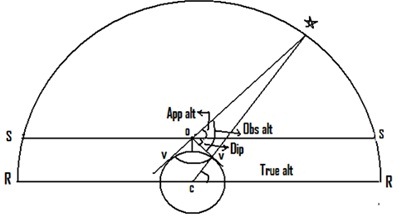
Corrections of Sextant Altitude
  • Visible horizon: Is the small circle on the earth’s surface, bounding the observer’s field of vision at sea.
  • Sensible horizon: Is a small circle on the celestial sphere, the plane of which passes through the observer’s eye, and is parallel to the observer’s rational horizon.
  • Rational horizon: The observer’s rational horizon is a great circle on the celestial sphere every point on which is 90° away from his zenith.
  • Observed altitude: Of a celestial body is the angle at the observer between the body and the direction to the observer’s visible or sea horizon. The observed altitude is therefore, the sextant altitude corrected for any index error.
  • Dip: Is the angle at the observer between the plane of observer’s sensible horizon and the direction to his visible horizon. Dip occurs because the observer is not situated at the sea level. The value of dip increases as the observer’s height.
  • Apparent altitude: Is the sextant altitude corrected for Index error and dip.
Posted on

Voyage Data Recorder (VDR)

Explanation of Voyage Data Recorder (VDR):

  • A VDR or voyage data recorder is an instrument installed on a ship to continuously record vital information related to the operation of a vessel.
  • It contains a voice recording system for a period of at least last 12 hours.
  • This recording is recovered and made use of for investigation in events of accidents.
  • The data records covering the last 12 hours are continuously overwritten by the latest data.
  • A VDR is capable of withstanding heavy weather, collisions, fires and pressure conditions even when a ship is at a depth of several meters in water.
Voyage Data Recorder (VDR)

Working of VDR:

  • There are various sensors placed on bridge of the ship and on prominent location from which the required data is continuously collected.
  • This data which comprises of voices, various parameters, ships location etc. are then fed to a storage unit where the whole input is recorded and saved for at least 12 hours.
  • There is also a record button provided in the bridge unit so that after pushing button (say during starting of any incident like collision or grounding), the recorder will start recording new set of information from that period of time.
  • The data collected by VDR is digitalised, compressed, and is stored in a protective storage unit which is mounted in a safe place.
  • This tamper proof storage unit can be a retrievable fixed or floating unit connected with EPIRB for early location in the event of accident.

Main Components of VDR:

  • Data Management Unit: It acquires data from various sources using interfaces, processes and stores the data in a specified format.
  • Audio Module:
    • It consists of an audio mixer for recording audio from microphones placed in the wheelhouse, bridge wings, ECR and various other locations.
    • VHF audio signals can also be interfaced with this unit.
  • Final Recording Unit:
    • This is a fire resistant, pressure tight storage medium to store recorded data.
    • The capsule is resistant against shock, penetration, fire, deep sea pressure and immersion. Housed in a highly visible protective capsule which can withstand high temperatures (1100OC) and deep sea pressure of 6000 m.
  • Remote Alarm Module: This is a small panel connected to the Data Management Unit that will sound an alarm should any error or fault develop in the equipment.
  • Replay Station:
    • This is an optional module for downloading and replaying the recorded data.
    • The data when played back can help in casualty investigations as well as for self analysis.
  • Information Recorded:-
    • Date & Time from GPS every 1s
    • Position & Datum – Lat/Long and datum from GPS, Loran-C etc. The source of data is identified on playback.
    • Speed (water / ground) recorded every 1s to 0.1k resolution
    • Heading (gyro or magnetic) is recorded at intervals of 1s to a resolution of 0.1 deg
    • Auto pilot settings for speed, latitude, rudder limit, off-course alarms etc.
    • Bridge audio in real time, both internal & external (150-6000Hz). The mic test beeps every 12 hrs & this is recorded.
    • Radar image recorded every 15s includes range rings, EBLs, VRMs, radar maps, parts of SENC & other essential navigational indications.
    • Wind speed/direction from the Anemometer is recorded & stored individually with time stamps.
    • VHF communication from 2 VHFs are recorded for both transmitted and received audio signals. Audio is compressed and labeled VHF 1 & VHF 2.
    • Hull openings & watertight doors status is received every 1s and stored with time stamps
    • Hull stresses are received and stored with time stamps.
    • Thruster status (bow/stern) can be recorded for their order and response
    • Rudder order and response angle is recorded to a resolution of 1 deg
    • Engine order and response from the telegraph or direct engine control with shaft revolution and ahead and astern indicators are recorded to a resolution of 1 rpm
    • AIS target data is recorded as a source of information regarding other ships.
    • Alarms are recorded with time stamps. All IMO mandatory alarms as well as other audible alarms are stored individually by the bridge audio microphones.

Purpose of VDR:

  • The main purpose of VDR is to record and store ship’s critical parameters to facilitate reconstruction of the incident for the purpose of analysis
  • Additionally navigator can use this for self-analysis, as lessons-learning tool and thus improvement of procedures in the future.
  • VDR can be used to identify cause of an accident and thus make major contribution to maritime safety.
    • The benefits are:
    • Promotion of safe practices
    • Accident investigation and enquiry
    • Response assessment and study
    • Training aid and support
    • Reduction in insurance costs
    • Statistics generation

VOYAGE DATA RECORDER – DATA ITEMS TO BE RECORDED:- IMO Performance Standard (Res. A.861(20)) and IEC Information format (IEC 61996).

DATA ITEM SOURCE
Date & Time Preferably external to ship (e.g.GNSS)
Ship’s position Electronic Positioning system
Speed (through water or over ground) Ship’s SDME
Heading Ship’s compass
Bridge Audio 1 or more bridge microphones
Comms. Audio VHF
Radar data- post display selection Master radar display
Water depth Echo Sounder
Main alarms All mandatory alarms on bridge
Rudder order & response Steering gear & autopilot
Engine order & response Telegraphs, controls and thrusters
Hull openings status All mandatory status information displayed on bridge
Watertight & fire door status All mandatory status information displayed on bridge
Acceleration & hull stresses Hull stress and response monitoring equipment where fitted
Wind speed & direction Anemometer when fitted

Recovery of VDR: Recovery of the VDR is conditional on the accessibility of the VDR or the data contained therein.

  • In the case of a non-catastrophic accident, recovery of the memory should be straightforward. For example, in some VDRs it can be accomplished by removal of a hard disc from the VDR unit. This action will have to be taken soon after the accident to best preserve the relevant evidence for use by both the investigator and the ship owner. As the investigator is very unlikely to be in a position to instigate this action soon enough after the accident, the owner must be responsible, through its on-board standing orders, for ensuring the timely preservation of this evidence in this circumstance.
  • In the case of abandonment of a vessel during an emergency, masters should, where time and other responsibilities permit, recover the memory and remove it to a place of safety and preserve it until it can be passed to the investigator.
  • In the case of a catastrophic accident, where the VDR is inaccessible and the data has not been retrieved prior to abandonment, a decision will need to be taken by the Flag State in co-operation with any other substantially interested States on the viability and cost of recovering the VDR balanced against the potential use of the information. If it is decided to recover the VDR the investigator should be responsible for co-ordinating its recovery. The possibility of the capsule having sustained damage must be considered and specialist expertise will be required to ensure the best chance of recovering and preserving the evidence. In addition the assistance and co-operation of the owners, insurers and the manufacturers of the VDR and those of the protective capsule may be required.

Posted on

Long Range Identification and Tracking (LRIT)

Long Range Identification and Tracking (LRIT) system architecture Explanation:

Purpose of LRIT:-

  • The Long Range Identification and Tracking (LRIT) system is a designated International Maritime Organization (IMO) system designed to collect and disseminate vessel position information received from IMO member States ships.
  • The main purpose of the LRIT ship position reports is to enable a Contracting Government to obtain ship identity and location information in sufficient time to evaluate the security risk posed by a ship off its coast and to respond, if necessary, to reduce any risks.
  • LRIT has also become an essential component of SAR operations and marine environment protection.
  • It is a satellite-based, real-time reporting mechanism providing almost worldwide coverage (Inmarsat Coverage) that allows unique visibility to position reports of vessels that would otherwise be invisible and potentially a threat.

CARRIAGE REQUIREMENT of LRIT :- Ships in international voyages

  • Passenger ships
  • Cargo ships over 300 t
  • Mobile platforms

Ships fitted with AIS and sailing in sea A1 areas do not need to transmit LRIT data.

INFORMATION TRANSMITTED in LRIT :-

  • Identity (Ship’s LRIT Identifier)
  • Position (Lat/Long)
  • Date and time (UTC)

UPDATE INTERVAL in LRIT:-

  • Default value 6 hourly
  • Update interval remotely selectable
  • Minimum interval 15 min
  • May be switched off by the Master under certain conditions
Long Range Identification and Tracking (LRIT) system architecture

THE LRIT SYSTEM CONSISTS OF:

  1. The ship borne LRIT information transmitting equipment.
  2. Communications Service Providers (CSPs).
  3. Application Service Providers (ASPs).
  4. LRIT Data Centres (DC), including any related Vessel Monitoring System(s) (VMSs).
  5. The LRIT Data Distribution Plan (DDP).
  6. The International LRIT Data Exchange (IDE),
  7. LRIT coordinator

How does LRIT differ from AIS Explanation:

  • Some confuse the functions of LRIT with that of AIS (Automatic Identification System), a collision avoidance system also mandated by the IMO, which operates in the VHF radio band, with a range only slightly greater than line-of-sight.
  • (See AIS) While AIS was originally designed for short-range operation as a collision avoidance and navigational aid, it has now been shown to be possible to receive AIS signals by satellite in many, but not all, parts of the world. This is becoming known as S-AIS and is completely different from LRIT.
  • The only similarity is that AIS is also collected from space for determining location of vessels, but requires no action from the vessels themselves except they must have their AIS system turned on.
  • LRIT requires the active, willing participation of the vessel involved, which is, in and of itself, a very useful indication as to whether the vessel in question is a lawful actor.
  • Thus the information collected from the two systems, S-AIS and LRIT, are mutually complementary, and S-AIS clearly does not make LRIT superfluous in any manner.
  • Indeed, because of co-channel interference near densely populated or congested sea areas satellites are having a difficult time in detecting AIS from space in those areas.

Authorized receivers / users of LRIT

LRIT Data Centres:-

  • The primary purposes of an LRIT Data Centre (DC) are to collect, store and make available to authorised entities the LRIT information transmitted by ships instructed by their administrations to utilise the services of that DC. In carrying out these core functions, the DC is required to ensure that LRIT data users are only provided with the LRIT information they are entitled to receive under the terms of SOLAS Regulation V/19.1.
  • In addition, the LRIT DC acts as a “clearing house” by receiving requests for LRIT information lodged in other DCs from its associated Administration(s) and obtaining the data requested. Generally LRIT reports so requested will be exchanged through the International Data Exchange.
  • LRIT Data Centers are required to archive their data so that the reports can be recovered, if required, at a later date and the activities of the DC can be audited by the LRIT Coordinator.
  • LRIT DCs may make a charge for LRIT data they provide to other DCs.
  • DCs may be either National (established to provide service to only one Contracting Government); Cooperative (established to provide services to a number of Contracting Governments) or Regional (established to provide services to a number of Contracting Governments acting through a regional entity of some kind). The IMO Performance Standard envisages also an International Data Centre (IDC), to provide LRIT services on an international basis to many countries that do not wish to establish their own DCs, but the IMO Maritime Safety Committee (MSC) has not yet decided to establish such an IDC.

Functions of LRIT National Data Centre

  • The International LRIT Data Exchange (IDE) exists to route LRIT information between LRIT DCs using the information provided in the LRIT Data Distribution Plan. It is therefore connected via the internet to all LRIT DCs and the LRIT Data Distribution Plan server.
  • The IDE cannot access and does not archive the LRIT data itself, but it does maintain a journal of message header information – which can be understood as the “envelope” containing the LRIT information. This journal is used for invoicing functions and for audit purposes.
  • The performance of the IDE is audited by the LRIT Coordinator.

How does LRIT differ from AIS?

Explanation:-

  • AIS is a broadcast system and data is available to all receiver in the receiving range whereas LRIT is available only to the authorized person.
  • AIS works on the very high frequency, whereas LRIT is based on the satellite system.
  • AIS range is limited to the VHF range but LRIT range is worldwide.
  • AIS DATA is not stored by any organization whereas LRIT data is stored and available on demand.
  • There is display for AIS ON BOARD but there is no display for LRIT on board the ship.


Compare the AIS & LRIT:

AISLRIT
SatelliteVHF
GlobalOnly where AIS coverage is provided
Secure DataPublic Data
Position, IMO Number, Date TimePosition, IMO Number, Date Time, Vessel Type, Speed, Course
Unlimited rangeLine of sight, up to 40NM
Flag State Owns DataAnyone can see data
Maritime Security and AwarenessNavigation and Anti-collision Tool
Comparison between AIS & LRIT

Posted on

Electronic Chart Display and Information System (ECDIS) on Ships

Electronic Chart Display and Information System (ECDIS) Explanation:-

  • Electronic Chart Display and information Systems (ECIDS) means a navigation information system which with adequate back-up arrangements can be accepted as complying with the up-to-date chart required by regulation V/20 of the 1974 SOLAS Convention, by displaying selected information from a system electronic navigational chart (SENC) with positional information from navigation sensors to assist the mariner in route Monitoring, and if required display additional navigation related information.
  • Generation of ECDIS:-
    • The electronic navigation chart is the data base standardized as to content, structure and format and is issued by the hydrographic office (HO) under the authority of the government, the ENC contains all the chart information necessary for safe navigation and may contain supplementary information in addition to that contained in the paper chart (e.g. list of lights and fog signals etc.) which may be considered necessary for safe navigation.
    • The system electronic navigation chart (SENC) is the data base resulting from transformation of the ENC by the ECDIS for appropriate use, updates to the ENC by appropriate means and other data added by the mariner. It is the data base that is actually accessed by the ECDIS for the display generations & other navigational functions and is equivalent to an up-to-date paper chart.
Electronic Chart Display and Information System (ECDIS) Flowchart

ECDIS is basically a CPU with a monitor to display electronic chart, SENC is an integral part and below figure can be referred for better understanding which shows that SENC is interfaced with various equipment as mentioned below results in an ECDIS.


Advantages of Electronic Chart Display and Information System (ECDIS):

  1. Availability: One of the great advantages of ECDIS over paper charts is the availability of electronic charts – especially when voyage orders are received at the last minute.
  2. Speed and Accuracy: With ECDIS as the primary source of navigation, the Navigating Officer can plan and summarise the passage much faster than on Paper Charts. Daily reporting data such as Distance to Go, Distance Covered, Average Speed, etc. can be done quickly with hardly any effort.
  3. Corrections: The Navigating Officer now receives weekly updates to the Electronic Charts via Email which he has to download onto a zip drive and upload them to the ECDIS. Even the dreaded T&P notices are now shown electronically on the ECDIS.
  4. Continuous Monitoring of Vessel’s Position: The ECDIS is interfaced with both the vessel’s independent GPS transceivers, thereby making the system work even if one fails.
  5. Anti-Grounding Alarms and Settings: The ability of the ECDIS to warn the user of approaching shallow waters make it one of the most useful equipment on the bridge.
  6. User Determined Alarm Settings: While there are certain safety critical alarms that are ON by defaults and cannot be changed, there are a host of other alarms and warnings which may be switched on or off by the User depending on the situation.
  7. Enhances Search and Rescue Capability onboard: Modern ECDIS units have the option of interfacing NAVTEX and EGC with the ECDIS display. Warnings and Alerts are automatically displayed on the ECDIS screen, whilst at the same time giving an audible and visual indication on the unit itself.
  8. Cost Efficient: Although, Electronic charts are by no means cheap, they still have an edge over paper charts dollar for dollar.
  9. Environmentally Friendly: The ECDIS does pack in a strong punch in reducing the carbon footprint of every vessel which goes paperless.

Disadvantages of Electronic Chart Display and Information System (ECDIS):

  1. Over-Reliance: A vessel could have switched off its AIS and hence might not be displayed on the ECDIS. If the Radar Overlay is not turned on, the vessel will just not be seen on the ECDIS display. Hence, it is very critical that Navigators continue to maintain an efficient lookout and a good radar watch.
  2. Garbage In Garbage Out (GIGO): Erroneous position inputs from the GPS or loss of GPS signal can have grave consequences with the ECDIS going in DR mode. If the alarm is missed out, the result can be disastrous.
  3. Wrong Settings: Feeding in wrong parameters for safety critical settings such as the Safety Depths, Safety Contours etc can give a false sense of safety.
  4. Alarm Deafness: If alarms start going off too frequently, the navigator could end up in a dangerous situation called Alarm Deafness.
  5. System Lag: Modern ECDIS software can have a lot of data to display and with various equipment interfaced with the ECDIS, the system can slow down very easily leading to system lag.
  6. Different Types: Different vessels will have different types of ECDIS equipment.
  7. Anomalies: Every navigator needs to be aware of the anomalies present in that particular equipment. It could be a simple use of the SCAMIN (Scale Minimum) function or something serious where certain depths or symbols might not be visible at a particular scale or appear differently.
  8. Information Overload: It is very easy to over feed information on the ECDIS. A lot of data which was earlier marked on charts such as position for calling Master notices to Engine Room, Echo Sounder Switch on points, Port Control VHF channels etc now have to be fed on the ECDIS.

Advantages of ECDIS over conventional Paper Charts:

  • Position fixing can be done at required interval without manual interference.
  • Continuous monitoring of the ship’s position.
  • When interfaced with ARPA/RADAR, target can be monitored continuously.
  • If two position fixing system are available, the discrepancy in two systems can be identified.
  • Charts can be corrected with help of CD/Online.
  • Passage planning can be done on ECDIS without referring to other publications.
  • Various alarms can be set on ECDIS.
  • Progress of the passage can be monitored in more disciplined manner, since other navigational data is available on ECDIS.
  • Various alarms can be activated to draw the attention of OOW.
  • More accurate ETA can be calculated.
  • Anchoring can be planned more precisely.

“Zones of Confidence” in ECDIS:-

  • The information presented in a reliability diagram requires knowledge of past and present hydrographic surveying practices — something most mariners neither have nor should need. To address this, the Australian Hydrographic Service developed a system known as “zones of confidence” that has since been adopted internationally.
  • On each nautical chart the accuracy and reliability of the information used to compile the chart is shown on a “zone of confidence” (ZOC) diagram. Within official electronic navigational charts (ENCs), the same information is shown as a layer that can be switched on and off by the mariner.
  • ZOC categories warn mariners which parts of the chart are based on good or poor information and which areas should be navigated with caution. The ZOC system consists of five quality categories for assessed data, with a sixth category for data which has not been assessed.
  • The table accompanying the ZOC diagram on each chart summarizes the meaning of the ZOC categories.

Define ENC as applicable to ECDIS:

Electronic Navigational Chart (ENC) means the database, standardized as to content, structure and format,  issued for use with ECDIS on the authority of government authorized hydrographic offices. The ENC contains all the chart information necessary for safe navigation and may contain supplementary information in addition to that contained in the paper chart (e.g. sailing directions) which may be considered necessary for safe navigation. Vector charts are an example.

Define SENC as applicable to ECDIS:

System Electronic Navigational Chart (SENC) means a database resulting from the transformation of the ENC (a vector chart) by ECDIS for appropriate use, updates to the ENC by appropriate means and other data added by the mariner. It is the database that is actually accessed by ECDIS for the display generation and other navigational functions and is the equivalent to an up-to-date paper chart. The SENC may also contain information from other sources.

Define Standard Display as applicable to ECDIS:

Standard Display means the SENC information that should be shown when a chart is first displayed on ECDIS. Depending upon the needs of the mariner, the level of the information it provides for route planning or route monitoring may be modified by the mariner.

Define Display Base as applicable to ECDIS:

Display Base means the level of SENC information which cannot be removed from the display, consisting of information which is required at all times in all geographic areas and all circumstances. It is not intended to be sufficient for safe navigation.

Define Vector Chart as applicable to ECDIS:

A vector chart is a digital database of all the objects (points, lines, areas, etc.) represented on a chart. Vector charts store information, such as isolated dangers, depths, depth contours, coastline features, cables and pipelines etc in separate layers which can be displayed as per the user’s requirements. Vector charts are also referred to as intelligent charts as they can be interrogated for information not displayed but stored in it’s memory.

Define Raster Chart as applicable to ECDIS:

Raster Chart data is created by scanning the information on a paper chart and storing this information in the form of pixels. Many thousands of pixels together make a flat digital image. Each pixel contains all the data for a particular point: colour, brightness etc. They are also geographically referenced which makes the raster chart identical in every way to the paper chart on which it is based. Raster charts cannot be manipulated or queried. Also referred to as the Raster Chart Display System (RCDS), the information is contained in one single layer only. Information can only be added to this type of chart.


Posted on

Automatic Identification System (AIS) on Ships

Automatic Identification System (AIS) Explanation:

  • Very simply, the Automatic Identification System is a broadcast transponder system, operating in the VHF maritime mobile band.
  • It is capable of sending information such as identification, position, course, speed and more, to other ships and to shore. AIS operates principally on two dedicated VHF frequencies or channels:

AIS 1 – 161.975 MHz – channel 87B (Simplex, for ship to ship)

AIS 2 – 162.025 MHz – channel 88B (Duplex for ship to shore)

Automatic Identification System AIS - Transmission
  • AIS uses Self-Organizing Time Division Multiple Access (SOTDMA) technology to meet this high broadcast rate and ensure reliable ship-to-ship operation. It normally works in an autonomous and continuous mode, regardless of whether it is operating in the open seas, coastal or inland areas.
  • Although only one radio channel is necessary, each station transmits and receives over two radio channels to avoid interference problems and to allow channels to be shifted without communications loss from other ships.
  • Each station determines its own transmission schedule (slot), based upon data link traffic history and knowledge of future actions by other stations.
  • A position report from one AIS station fits into one of 2250 time slots established every 60 seconds.
  • AIS stations continuously synchronize themselves to each other, to avoid overlap of slot transmissions.
  • Slot selection by an AIS station is randomized within a defined interval. When a station changes its slot assignment, it pre-announces both the new location and the timeout for that location.
  • In this way, new stations including those stations which suddenly come within radio range close to other vessels will always be received by those vessels.
  • Each AIS consists of on VHF transmitter, two VHF TDMA receivers, one VHF DSC receiver, and a standard marine electronic communications link to shipboard display and sensor systems.

Working of AIS:-

  • AIS is fitted with two receivers, one transmitter VHF DSC receiver Standard marine electronic communication link providing the various input data.
  • The AIS transmission uses 9.6 kb GMSK FM over 25 or 12.5kHz channel using HDLC Packet control.
  • Each AIS transmits and receives over two radio channel to avoid interference problems.
  • Each station determines its own transmission slot based on the data link traffic history and knowledge of future actions by other stations.
  • Range of AIS is about 20 NM.

Limitation of AIS:-

  • Small crafts may not be fitted with AIS
  • AIS might have switched off on other ship
  • Erroneous data might have entered
  • Accuracy of data received depend on the accuracy of data transmitted
  • Error in sensor’s input data,
  • Failure of sensors to provide data
  • Cell of vessel may be full

Precautions while using AIS in collision avoidance:-

  • AIS is an additional source of navigational information. It does not replace other navigational aids.
  • Should rely solely on AIS.
  • Watches must be kept as per STCW.
  • It does not have any impact on the composition of watch arrangement.
  • Swapping of targets.

Advantages of AIS:

  • AIS helps in collision avoidance with respect to situational awareness, AIS can calculate the CPA & TCPA which can be compared with ARPA.
  • Information regarding navigation status cane be beneficial.
  • By virtue of AIS vessels can be positively identified.
  • AIS reduced the work load associated with verbal reporting system required by the VTS.
  • AIS contributes to Maritime security, authorities can monitor the movement of the vessels, multiple AIS coast stations can be linked together to get the extended surveillance.
  • AIS can pick up targets even during heavy weather & restricted visibility especially due to rain etc.
  • AIS can pick up targets beyond small islands & bends.
  • Problem on target swap (for ARPA) will not be experienced in case of AIS.
  • No problem of range discrimination or bearing discrimination.
  • Pseudo AIS can be used to generate virtual buoys to indicate dangers.
  • AIS can also be installed on light houses, beacons for positive identification of these marks.
  • Pseudo AIS can also be used to generate target in case of SAR operations.
  • AIS can be used for meteorological & navigational information.
  • AIS can be interfaced with VDR, ECDIS & radar.

Limitations of AIS:

  • Small crafts may not be fitted with AIS
  • AIS might have switched off on other ship
  • Erroneous data might have entered
  • Accuracy of data received depend on the accuracy of data transmitted
  • Error in sensor’s input data,
  • Failure of sensors to provide data
  • Cell of vessel may be full

Precautions while using AIS in collision avoidance:

  • Do not rely on AIS as the sole  information  system, making use  of  all safety-relevant information available.
  • AIS is an additional source of navigational information. It does not replace other nav aids.
  • Watches must be kept as per STCW.
  • It does not have any impact on the composition of watch arrangement.
  • Swapping of targets.

Use of AIS in collision avoidance and SAR operations:

Use of AIS in Collision avoidance: AIS has potential to significantly contribute to safety of navigation. It provides positive identification of targets fitted with AIS along with their static and dynamic information.

This enhances the navigational effectiveness and it can greatly improve situational awareness and decision making abilities. AIS also assists OOW in tracking and monitoring targets, as it also provides information on CPA and TCPA.

Use of AIS in SAR operations:

  • SAR operations can be used for receiving messages from an AIS-SAR transmitter (SART), which have built in GPS receivers to derive accurate positioning information, on survival craft.
  • In combined aerial and surface searches AIS may allow the direct presentation of the position on other displays, such as radar, electronic chart systems and ECDIS.
  • AIS-SART facilitates the task of SAR craft in rescuing distressed seafarers.
  • For ships in distress without AIS, the on scene co-ordinator could create an AIS target.

Contents & broadcast intervals for each message type for a class A AIS:

  • A Class A AIS unit broadcasts the following information every 2 to 10 seconds while underway and every 3 minutes while at anchor at a power level of 12.5 watts.
  • The information broadcast includes:
    • MMSI number – unique reference able identification
    • Navigation status – not only are “at anchor” and “underway using engine“ currently defined, but “not under command” is also currently defined.
  • Rate of turn – right or left, 0 to 720 degrees per minute.
  • Speed over ground – 1/10 knot resolution from 0 to 102 knots.
  • Position accuracy – differential GPS or other and an indication if RAIM processing is being used Longitude – to 1/10000 minute and Latitude – to 1/10000 minute.
  • Course over ground – relative to true north to 1/10th degree.
  • True Heading – 0 to 359 degrees derived from gyro input.
  • Time stamp – The universal time to nearest second that this information was generated.
  • In addition, the Class A AIS unit broadcasts the following
  • information every 6 minutes:
    • MMSI number – same unique identification used above, links the data above to described vessel.
    • IMO number – unique reference able identification (related to ship’s construction).
    • Radio call sign – international call sign assigned to vessel, often used on voice radio.
  • Name – Name of ship, 20 characters are provided.
  • Type of ship/cargo – there is a table of possibilities that are available.
  • Dimensions of ship – to nearest meter.
  • Location on ship where reference point for position reports is located.
  • Type of position fixing device – various options from differential GPS to undefined.
  • Draught of ship – 1/10 meter to 25.5 meters [note “air-draught” is not provided].
  • Destination – 20 characters are provided.
  • Estimated time of Arrival at destination – month, day, hour, and minute in UTC.

AIS & LRIT Comparison:-

AISLRIT
SatelliteVHF
GlobalOnly where AIS coverage is provided
Secure DataPublic Data
Position, IMO Number, Date TimePosition, IMO Number, Date Time, Vessel Type, Speed, Course
Unlimited rangeLine of sight, up to 40NM
Flag State Owns DataAnyone can see data
Maritime Security and AwarenessNavigation and Anti-collision Tool

With Respect to AIS explain the followings: Dynamic Message

The dynamic data are sent as per the ship’s navigational status and speed and are as follows:

  • When at anchor every three minutes.
  • 0-14 kts-every 12 seconds
  • 14-23 kts-every 6 seconds
  • 14-23 kts and changing course every 2 seconds
  • 23+ kts every 2 seconds
Posted on

Global Positioning System (GPS) on Ships

Working of the Global Positioning System (GPS):

GPS or Global Positioning System is a satellite navigation system that furnishes location and time information in all climate conditions to the user. GPS is used for navigation in planes, ships, cars and trucks also. The system gives critical abilities to military and civilian users around the globe. GPS provides continuous real time, 3-dimensional positioning, navigation and timing worldwide.

GPS System Working:- The GPS system consists of three segments:

  1. The space segment: the GPS satellites.
  2. The control system, operated by the U.S. military.
  3. The user segment, which includes both military and civilian users and their GPS equipment.

Space Segment of GPS:

  • The space segment is the number of satellites in the constellation. It comprises of 29 satellites circling the earth every 12 hours at 12,000 miles in altitude.
  • The function of the space segment is utilized to route/navigation signals and to store and retransmit the route/navigation message sent by the control segment. These transmissions are controlled by highly stable atomic clocks on the satellites.
  • The GPS Space Segment is formed by a satellite constellation with enough satellites to ensure that the users will have, at least, 4 simultaneous satellites in view from any point at the Earth surface at any time.
Space segment of GPS

GPS Control Segment:

  • The control segment comprises of a master control station and five monitor stations outfitted with atomic clocks that are spread around the globe.
  • The five monitor stations monitor the GPS satellite signals and then send that qualified information to the master control station where abnormalities are revised and sent back to the GPS satellites through ground antennas. Control segment also referred as monitor station.
Control Segment of GPS

GPS User Segment:

  • The user segment comprises of the GPS receiver, which receives the signals from the GPS satellites and determine how far away it is from each satellite.
  • Mainly this segment is used for the U.S military, missile guidance systems, civilian applications for GPS in almost every field.
  • Most of the civilian uses this from survey to transportation to natural resources and from there to agriculture purpose and mapping too.
User Segment of GPS
User Segment of GPS

How GPS Determines a Position:

  • The working/operation of Global positioning system is based on the ‘trilateration’ mathematical principle.
  • The position is determined from the distance measurements to satellites. From the figure, the four satellites are used to determine the position of the receiver on the earth.
  • The target location is confirmed by the 4th satellite. And three satellites are used to trace the location place.
  • A fourth satellite is used to confirm the target location of each of those space vehicles. Global positioning system consists of satellite, control station and monitor station and receiver.
  • The GPS receiver takes the information from the satellite and uses the method of triangulation to determine a user’s exact position.
GPS Positioning

GPS Circuit: GPS is used on some incidents in several ways, such as:

  • To determine position locations; for example, you need to radio a helicopter pilot the coordinates of your position location so the pilot can pick you up.
  • To navigate from one location to another; for example, you need to travel from a lookout to the fire perimeter.
  • To create digitized maps; for example, you are assigned to plot the fire perimeter and hot spots.
  • To determine distance between two different points.

How a GPS receiver determines the ship’s position?

Position Fixing:
  • The receiver locks on to one satellite, and from this satellite it obtains the almanac of all the other satellites, and thereby selects the most suitable satellites for position fixing.
  • The position obtained by the receiver is basically by determining the distances from the receiver to each of the selected satellites.
  • The range measurement is achieved by measuring the propagation time from the selected satellite to the receiver.
  • Not possible to precisely synchronize satellite and receiver clock hence the pseudo ranges are obtained.
  • Hence an additional satellite is used to obtain the true ranges.
GPS Position Fixing of a ship
Equation for position fixing:-
  • R = C X (t-t2)
  • Range (R) of the satellite to the user.
  • Where C is the velocity of the radio waves and
  • (t-t2) = is the time difference (time taken for satellite signals to reach receiver.)

The satellite clock & the GPS clock may not be perfectly synchronized so this gives rise to an error in range measurement and the obtained is termed as pseudo range.

Hence, there are four unknowns i.e. latitudes, longitude, altitude (x, y, z co-ordinates) of the user as well as the user’s clock error with respect to satellite clock.

  • The position of the satellite S1 (x1, y1 , z1) is known to the user by the 30 sec navigational message and from this satellite the following equation is obtained:-
  • Where PR1 is the pseudo rage from satellite S1.
  • (C x Δt) is error in range measurement due to the error in the user’s clock.
  • Since there are four unknown, they can be resolved from four equations obtained from four different satellites, the other 3 equations will be following:

With the help of these equations the 3D-fix can be obtained. In the case of a craft floating on water, a 2-D fix (i.e. Lat & long) is required and 3 equations from 3 satellites will be sufficient to fix position.


Precise Positioning Service (PPS) of GPS:

  • Authorised users have access to Precise Positioning Service.
  • The L1 frequency, transmitted by all Navstar satellites, contains a course/acquisition (C/A) code ranging signal, with a navigation data message, that is available for peaceful civil, commercial, and scientific use; and a precision (P) code ranging signal with a navigation data message, that is reserved for authorized use.
  • PPS predictably is 30 meters.

Standard Positioning Service (SPS) of GPS:-

  • Civil Users worldwide use SPS.
  • The L1 frequency, transmitted by all satellites, contains a coarse/ acquisition (C/A) code ranging signal, with a navigation data message, that is available for peaceful civil, commercial, and scientific use.
  • SPS predictability Accuracy: within 35 meters.
  • It is subject to selective availability, intentional down gradation of accuracy.
  • Now it has been announced by US Govt, that intentional down gradation will not be done.

Errors of GPS:

GPS Errors Sources
  1. Atmospheric Error: Changing atmospheric conditions change the speed of the GPS signals as they pass through the Earth’s atmosphere and this affects the time difference measurement and the fix will not be accurate. Each satellite transmits its message on two frequencies and hence a dual frequency receiver receives both the frequencies and correction is calculated and compensated within the receiver thus increasing the accuracy of the fix.
    • Effect is minimized when the satellite is directly overhead.
    • Becomes greater for satellites nearer the horizon. The receiver is designed to reject satellites with elevation less than 9.5 degrees.
  2. User Clock Error: If the user clock is not perfectly synchronised with the satellite clock, the range measurement will not be accurate. The range measurement along with the clock error is called pseudo range. This error can be eliminated within the receiver by obtaining pseudo range from three satellites and is done automatically within the receiver.
  3. Satellite Clock Error: This error is caused due to the error in the satellite’s clock w.r.t. GPS time. This is monitored by the ground based segments and any error in the satellites clock forms part of the 30 seconds navigational message.
  4. GDOP Error: The GDOP of a satellite determines the angle of cut which in turn governs the quality of the position obtained. Wider the angular separation between the satellites, better the accuracy of the fix. Or, conversely said, the lower the GDOP value, the greater the accuracy of the fix. The GDOP value is indicated on the display unit.
  5. Multipath Error: This error is caused by the satellite signals arriving at the ship’s antenna both directly from the satellite and those that get reflected by some objects. Thus two signals are received simultaneously which will cause the distortion of signal from which range measurement is obtained. Siting the antenna at a suitable place can minimize this error.
  6. Orbital Error: The satellites are monitored and their paths are predicted by the ground based segment. However, between two consecutive monitoring of the same satellite, there may be minor drifts from their predicted paths resulting in small position inaccuracy.

Contents of Navigation Message transmitted by the GPS satellites:

Navigation Message: Essential purpose of the navigation message transmission by satellites is to determine its position by the GPS receiver. Each satellite transmits a navigational message of 30 seconds in the form of 50 bps data frame. This data, which is different for each satellite, is previously supplied to the satellites by master control station and is divided into 5 sub-frames.

Each sub-frame commences with telemetry word (TLM) containing satellite status followed by hand over word (HOW) data for acquiring P code from C/A code.

Navigational Message of GPS

The sub-frames are:

  • The 1st sub-frame contains data relating to satellite clock correction.
  • The 2nd and 3rd sub-frames contain the satellite ephemeris defining the position of the satellite.
  • The 4th sub-frame passes the alpha-numeric data to the user and will only be used when upload station has a need to pass specific messages.
  • The 5th sub-frame gives the almanac of all the other satellites which includes the identity codes thus allowing the user the best choice of satellites for position fixing.

Differential GPS (DGPS) enhances the accuracy of the ship’s position:

Differential GPS (DGPS) is a system in which differences between observed and computed co-ordinates ranges (known as differential corrections) at a particular known point are transmitted to users (GPS receivers at other points) to upgrade the accuracy of the users receivers position.

Differential Correction:- Differential correction is a technique that greatly increases the accuracy of the collected DGPS data. It involves using a receiver at a known location – the “base station“ and comparing that data with DGPS positions collected from unknown locations with “roving receivers.”

Limitation & Errors of DGPS:-

  1. International Limitation of Accuracy
  2. Receiver Independent Exchange Format
  3. Reference System Co-ordinates

Methods used to Transmit Corrections:-

  • Computing & transmitting – a position correction in terms of Lat, Long & altitude i.e. x, y, z co-ordinates.
  • Computation of pseudo range correction to each satellite which is then broadcasted to the user and applied to the user’s pseudo range measurement before the position is calculated by the onboard receiver resulting in a higher accuracy of position fix.
  • DGPS removes common-mode errors, those errors common to both the reference and remove receivers (not multipath or receiver noise). Errors are more often common when receivers are close together (less than 100 km). Differential position accuracies of 1-10 meters are possible with DGPS based on C/A code SPS Signal.
Differential GPS enhances the accuracy of the ship’s position

Explanation of how the DGPS calculate even more accurate position than the GPS:

  • Differential Global Positioning System (DGPS) is an enhancement to Global Positioning System that provides improved location accuracy, from the 15-meter nominal GPS accuracy to about 10 cm in case of the best implementations.
  • DGPS uses a network of fixed ground-based reference stations to broadcast the difference between the positions indicated by the GPS satellite systems and the known fixed positions.
  • These stations broadcast the difference between the measured satellite pseudo ranges and actual (internally computed) pseudo ranges, and receiver stations may correct their pseudo ranges by the same amount.
  • The digital correction signal is typically broadcast locally over ground-based transmitters of shorter range.

Geodetic Datum:

A geodetic datum or geodetic system is a coordinate system, and a set of reference points, used for locating places on the Earth (or similar objects). Datums are used in geodesy, navigation, and surveying by cartographers and satellite navigation systems to translate positions indicated on maps (paper or digital) to their real position on Earth. Each starts with an ellipsoid (stretched sphere), and then defines latitude, longitude and altitude coordinates. One or more locations on the Earth’s surface are chosen as anchor “base-points”.

Pseudo Range:

The Pseudo Range is the pseudo distance between a satellite and a navigation satellite receiver for instance Global Positioning System (GPS) receivers. To determine its position, a satellite navigation receiver will determine the ranges to (at least) four satellites as well as their positions at time of transmitting. Knowing the satellites’ orbital parameters, these positions can be calculated for any point in time. The Pseudo Ranges of each satellite are obtained by multiplying the speed of light by the time the signal has taken from the satellite to the receiver. As there are accuracy errors in the time measured, the term pseudo-ranges is used rather than ranges for such distances.

True Range:

True Range is an instantaneous measurement of the distance between the transmit antenna on the SV and receive antenna on the vehicle.  If it were possible imagine a tape measure stretched out between the two antennas, this measurement is the true range.


Geometric Dilution of Precision (GDOP):

Explanation:-

  • Dilution of precision (DOP), or geometric dilution of precision (GDOP), is a term used in satellite navigation and geomatics engineering to specify the additional multiplicative effect of navigation satellite geometry on positional measurement precision.
  • DOP can be expressed as a number of separate measurements:
    • HDOP – horizontal dilution of precision
    • VDOP – vertical dilution of precision
    • PDOP – position (3D) dilution of precision
    • TDOP – time dilution of precision
  • These values follow mathematically from the positions of the usable satellites. Signal receivers allow the display of these positions (skyplot) as well as the DOP values.
  • The term can also be applied to other location systems that employ several geographical spaced sites. It can occur in electronic-counter-counter-measures (electronic warfare) when computing the location of enemy emitters (radar jammers and radio communications devices). Using such an interferometry technique can provide certain geometric layout where there are degrees of freedom that cannot be accounted for due to inadequate configurations.
  • The effect of geometry of the satellites on position error is called geometric dilution of precision and it is roughly interpreted as ratio of position error to the range error. Imagine that a square pyramid is formed by lines joining four satellites with the receiver at the tip of the pyramid. The larger the volume of the pyramid, the better (lower) the value of GDOP; the smaller its volume, the worse (higher) the value of GDOP will be. Similarly, the greater the number of satellites, the better the value of GDOP.

HDOP with respect to GPS:

HDOP: Acronym for horizontal dilution of precision. A measure of the geometric quality of a GPS satellite configuration in the sky. HDOP is a factor in determining the relative accuracy of a horizontal position. The smaller the DOP number, the better the geometry.


GPS receiver determining the speed of the ship:

Explanation:

  • The carrier frequency is also used to determine the speed of the user by the measurement of Doppler shift, i.e. change in the frequency of radio waves received when the distance between the satellite and user is changing due to the relative motion between the two.
  • The position and velocity of the satellite as well as the position of the user are known to the user’s receiver.
  • The velocity vector of the satellite can be resolved in two ways:
    • In the direction towards the user
    • In the direction perpendicular to (i).
  • The 2nd component is not considered as speed in this direction will not cause Doppler shift.
  • The receiver calculates the velocity vector of the satellite in the direction towards the user.
  • If the relative approach speed between the satellite and the user’s speed (based on the Doppler shift measurement) is not equal to the satellite speed vector towards the user; the difference can only arise due to user’s speed towards or away from the satellite.
  • Similarly with the help of the other two satellites, the receiver can calculate two additional speed vectors and these speed vectors will be towards or away from their respective satellites.
  • These velocity vectors are resolved into three other vectors, i.e. x, y and z co-ordinates and with these three vectors the course and speed of the user is calculated.

GPS System configuration and frequencies used for: P & C/A code:

Codes:- Each satellite transmits two codes:-

  • P Code (Precession Code) that is only available to US military and its allies.
  • C/A Code (Coarse Acquisition Code) available for use to all civilian users.

Frequencies:- 1575.42 MHz (L1 signal) and 1227.6 MHz (L2 signal).

  • The L1 carrier consists of both the C/A and P codes, while the L2 carrier consists the P code only.
  • Each satellite transmits pseudo random noise signals on these two different frequencies.

Function of these codes is as follows:

  • For satellite identification since each satellite has a unique code.
  • For measurement of the propagation time from the satellite to user.

The C/A code:-

  • The C/A code is different for every satellite.
  • The C/A code is made up of sequences called chips.
  • Sequence repeats itself every millisecond.
  • The C/A code is for the civilians.
C_A Code of GPS on ships

P code:-

  • The full code length is of 267 days.
  • The extremely long code length makes it difficult to lock on to the P code.
  • P code is available only for US & allies.
  • P code is different for every satellite.

Alarms of GPS on Ships:

Alarms of GPS:- There are seven alarm conditions which generate both audible and visual alarms. When an alarm setting is violated, the buzzer sounds and the name of the offending alarm appears on the display. The alarm icon also appears on the Plotter 1, Plotter 2 and Highway displays.

  1. Arrival Alarm, Anchor Watch Alarm:-
    • Arrival alarm:- The arrival alarm informs you that own ship is approaching a destination waypoint. The area that defines an arrival zone is that of a circle which you approach from the outside of the circle.
    • Anchor watch alarm:- The anchor watch alarm sounds to warn you that own ship is moving when it should be at rest.
  2. Cross Track Error (XTE) Alarm :- The XTE alarm warns you when own ship is off its intended course.
  3. Ship’s Speed Alarm:- The ship’s speed alarm sounds when ship’s speed is lower or higher (or within) the alarm range set.
  4. Trip Alarm:-  The trip alarm sounds when the distance run is greater than the trip alarm setting.
  5. Water Temperature Alarm:- The water temperature alarm sounds when the water temperature is higher or lower (or within) the preset temperature. This alarm requires temperature signal from external equipment.
  6. Depth Alarm:- The depth temperature alarm sounds when the depth is higher or lower (or within) the preset depth. This alarm requires video sounder connection.
  7. WAAS/DGPS Alarm:- The WAAS/DGPS alarm sounds when the WAAS/DGPS signal is lost. This alarm may be enabled or disabled as below.

Chart Datum – Explanation:

Chart Datum (CD) is defined simply in the Glossary as the level below which soundings are given on Admiralty charts. CDs used for earlier surveys were based on arbitrary low water levels of various kinds.

Modern Admiralty surveys use as CD a level as close as possible to Lowest Astronomical Tide (LAT), which is the lowest predictable tide under average meteorological conditions. This is to conform to an IHO Technical Resolution which states that CD should be set at a level so low that the tide will not frequently fall below it.

The actual levels of LAT for Standard Ports are listed in Admiralty Tide Tables. On larger scale charts, abbreviated details showing the connection between chart datum and local land levelling datum are given in the tidal panel for the use of surveyors and engineers, where those connections are known.

Datums in use on charts:-

Large scale modern charts contain a panel giving the heights of MHWS, MHWN, MLWS and MLWN above CD, or MHHW, MLHW, MHLW and MLLW, whichever is appropriate, depending on the tidal regime in the area concerned. The definitions of all these terms are given in the Glossary. If the value of MLWS from this panel is shown as 0·0 m, CD is the same as MLWS and is not therefore based on LAT. In this case tidal levels could fall appreciably below CD on several days in a year, which happens when a CD is not based on LAT.

Other charts for which the UKHO is the charting authority are being converted to new CDs based on LAT as they are redrawn. The new datum is usually adopted in Admiralty Tide Tables about one year in advance to ensure agreement when the new charts are published. When the datum of Admiralty Tide Tables thus differs from that of a chart, a caution is inserted by Notice to Mariners on the chart affected drawing attention to the new datum.

Where foreign surveys are used for Admiralty charts, the chart datums adopted by the hydrographic authority of the country concerned are always used for Admiralty charts. This enables foreign tide tables to be used readily with Admiralty charts. In tidal waters these CDs may vary from Mean Low Water (MLW) to lowest possible low water. In non–tidal waters, such as the Baltic, CD is usually Mean Sea Level (MSL). Caution. Many CDs are above the lowest levels to which the tide can fall, even under average weather conditions. Charts therefore do not always show minimum depths.

For further details, see the relevant Admiralty Tidal Handbook.